


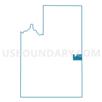
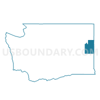
Voting District 9020, Spokane County, Washington
About
Outline

Summary
| Unique Area Identifier | 689477 |
| Name | Voting District 9020 |
| County | Spokane County |
| State | Washington |
| Area (square miles) | 15.33 |
| Land Area (square miles) | 15.33 |
| Water Area (square miles) | 0.00 |
| % of Land Area | 100.00 |
| % of Water Area | 0.00 |
| Latitude of the Internal Point | 47.60228290 |
| Longtitude of the Internal Point | -117.09390990 |
Maps

Graphs
Select a template below for downloading or customizing gragh for Voting District 9020, Spokane County, Washington


Neighbors
Neighoring Voting District (by Name) Neighboring Voting District on the Map
- Voting District 055063, Kootenai County, ID
- Voting District 055066, Kootenai County, ID
- Voting District 4026, Spokane County, WA
- Voting District 4029, Spokane County, WA
- Voting District 9013, Spokane County, WA
- Voting District 9014, Spokane County, WA
- Voting District 9015, Spokane County, WA
Top 10 Neighboring County Subdivision (by Population) Neighboring County Subdivision on the Map
- Spokane CCD, Spokane County, WA (353,581)
- Post Falls-Rathdrum CCD, Kootenai County, ID (46,624)
- Liberty Lake CCD, Spokane County, WA (16,620)
- Valleyford CCD, Spokane County, WA (2,913)
Top 10 Neighboring Unified School District (by Population) Neighboring Unified School District on the Map
- Central Valley School District, WA (76,487)
- Coeur d'Alene School District 271, ID (71,692)
- Post Falls School District 273, ID (36,257)
- Freeman School District, WA (4,305)
Top 10 Neighboring State Legislative District Lower Chamber (by Population) Neighboring State Legislative District Lower Chamber on the Map
- State House District 4, WA (141,254)
- State House District 9, WA (136,166)
- State House District 5, ID (46,466)
Top 10 Neighboring State Legislative District Upper Chamber (by Population) Neighboring State Legislative District Upper Chamber on the Map
- State Senate District 4, WA (141,254)
- State Senate District 9, WA (136,166)
- State Senate District 5, ID (46,466)
Top 10 Neighboring 111th Congressional District (by Population) Neighboring 111th Congressional District on the Map
Top 10 Neighboring Census Tract (by Population) Neighboring Census Tract on the Map
- Census Tract 131, Spokane County, WA (9,678)
- Census Tract 132.02, Spokane County, WA (9,217)
- Census Tract 130, Spokane County, WA (7,487)
- Census Tract 4.01, Kootenai County, ID (5,834)
- Census Tract 133, Spokane County, WA (2,913)